CNN
—
Residents on the small resort island of Polillo are accustomed to severe weather – their island sits in the northeastern Philippines, on the edge of the Pacific Ocean where storms typically gather strength and turn into typhoons.
But even they were stunned by the intensity of Typhoon Noru, known locally as Typhoon Karding, that turned from a typhoon into a super typhoon in just six hours before hitting the region earlier this week.
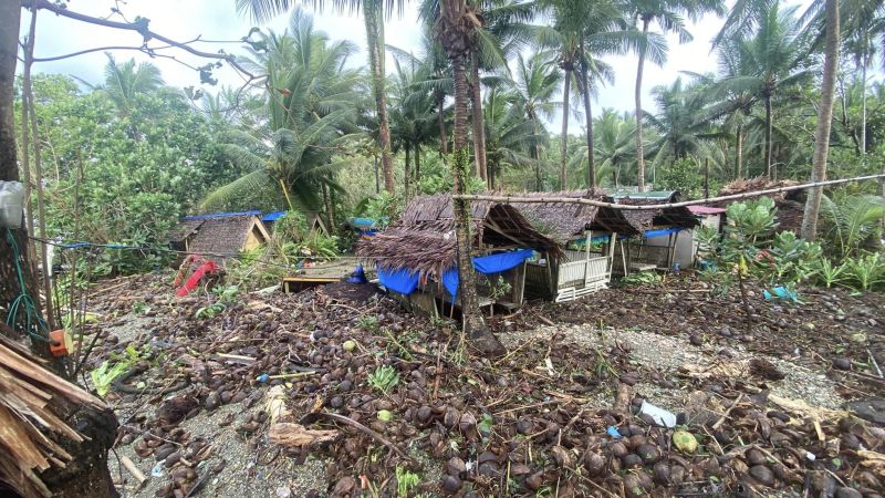
“We’re used to typhoons because we’re located where storms usually land,” said Armiel Azas Azul, 36, who owns the Sugod Beach and Food Park on the island, a bistro under palm trees where guests drink coconut juice in tiny thatched huts.
“But everything is very unpredictable,” he said. “And (Noru) came very fast.”
The Philippines sees an average of 20 tropical storms each year, and while Noru didn’t inflict as much damage or loss of life as other typhoons in recent years, it stood out because it gained strength so quickly.
Experts say rapidly developing typhoons are set to become much more common as the climate crisis fuels extreme weather events, and at the same time it will become harder to predict which storms will intensify and where they will track.
“The challenge is accurately forecasting the intensity and how fast the categories may change, for example from just a low-pressure area intensifying into a tropical cyclone,” said Lourdes Tibig, a meteorologist and climatologist with the Institute for Climate and Sustainable Cities.
The same happened in the United States last week when Hurricane Ian turned from a Category 1 storm into a powerful Category 4 hurricane before making landfall along the southwestern coast of Florida on Wednesday.
Such rapid intensification, as it’s known in meteorological terms, creates challenges for residents, authorities and local emergency workers, including those in the Philippines, who increasingly have no choice but to prepare for the worst.
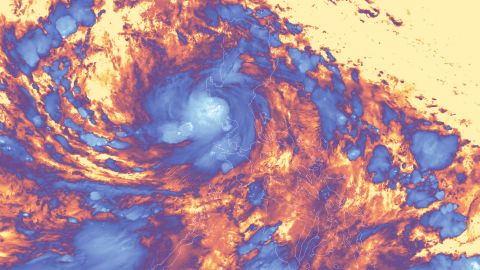
When Azul received warning that Typhoon Noru was approaching the Philippines last Saturday, he began his usual preparations of setting up his generator and tying down loose items.
At that stage, Noru was predicted to make landfall on Sunday as the equivalent of a Category 1 hurricane.
But as the storm grew closer, it strengthened into a super typhoon, the equivalent of a Category 5 hurricane, making landfall Sunday evening with ferocious winds that lifted waves and lashed properties on the shoreline.
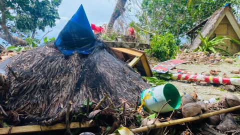
Azul said his community was fortunate to have TV signal in the resort, and as soon as they found out that the typhoon was much stronger than forecast, his staff brought in all the bistro’s outdoor furniture and tied down the roofs of their guesthouses, while local government units evacuated people living near the shore.
“But other parts of the island which don’t have internet connectivity and only rely on radio signals might not have got the message in time,” he said.
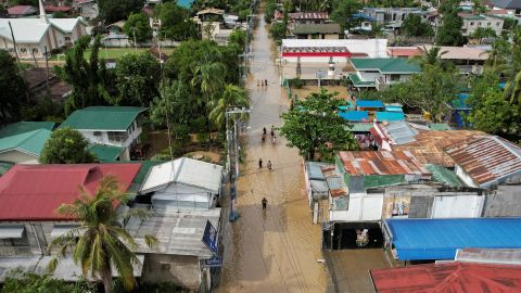
The typhoon damaged the resort town, as strong winds toppled beach huts and damaged nearby fishing cages.
Azul added that coconut trees planted across the island about a decade ago after Typhoon Ketsana (Ondoy) battered the area had just started to bear fruit but were now completely wiped out.
“We have to pick up the pieces, and rebuild again,” he said.

On the main island of Luzon, Noru left a trail of destruction in the province of Nueva Ecija, known as the “rice granary” of the country.
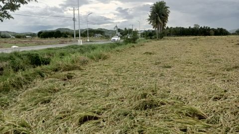
Ruel Ladrido, 46, a farmer owner in Laur, Nueva Ecija, said his rice fields were not flooded but strong winds damaged his crops.
“It didn’t rain hard near me, but the winds uprooted some of my fields. It will affect our harvest this season, but what can we do? I don’t know the extent of the damage yet, but we’ll have to plant again,” he told CNN on Tuesday.
As of Friday, 12 people had died in the aftermath of Noru, including five rescue workers in Bulacan province, according to the National Disaster Risk Reduction and Management Council (NDRRMC).
The estimated damage to agriculture ballooned to some 3 billion Philippine pesos (about $51 million), affected 104,500 farmers and fisher folk, and damaged over 166,630 thousand hectares of crop land, according to the NDRRMC.
The Philippines, an archipelago of more than 7,600 islands, is already vulnerable to typhoons, but as sea levels rise and ocean temperatures warm, the storms expected to become more powerful, according to research published in 2018.
The study found that the stronger typhoons carry more moisture and track differently. They are also “aggravated by sea level rise, one of the most certain consequences of climate change.”
A separate study published last year, by researchers at the Shenzhen Institute of Meteorological Innovation and the Chinese University of Hong Kong, found that typhoons in east and southeast Asia now last between two and nine hours longer and travel an average of 100 kilometers (62 miles) further inland than they did four decades ago. By the end of the century, they could have double the destructive power.
As such, it’ll become more difficult to forecast their track and predict ones that will quickly gain strength, or undergo rapid intensification – defined as when wind speeds increase by at least 35 miles per hour (56 kilometers per hour) in 24 hours or less.
Although rare, the Philippines is no stranger to this phenomenon as 28% of all tropical cyclones that made landfall in the country dating back to 1951 underwent rapid intensification based on official data, according to Gerry Bagtasa, a professor with the University of the Philippines’ Institute of Environmental Science and Meteorology.
Bagtasa said factors such as high moisture, warm ocean surface temperatures and low wind shear determine the scale of rapid intensification, but those weather readings “don’t have to be extraordinary in their values” to create rapid intensification.
He remarked that Typhoon Noru’s track across the Philippine Sea before making landfall was “just average for this season” and the wind shear – or the change of wind speed and strength with height in the atmosphere – was not extraordinarily low.
Bagtasa also said forecasters find it difficult to predict rapid intensification in the Pacific, because even though satellite monitoring has improved, there isn’t enough data to forecast worsening weather events.
“There are also many unprecedented events happening recently worldwide, and since forecasters typically rely on their past experiences, new events can ‘throw off’ forecasts, so to speak,” he said.
Mirian Abadilla, a doctor and municipal health officer in Cabangan, Zambales province, on the Philippine island of Luzon, has been involved in her community’s disaster management response since 1991.
She says in that time, typhoons have become harder to forecast, and her community has no choice but to prepare for the worst.
“The typhoons are definitely getting stronger because of climate change, and getting harder to predict,” she said. “But each time we get hit with a typhoon, we try to keep improving our disaster response – that’s the only way for us to stay alert.”
She said local governments held meetings as Typhoon Noru approached the coast to go over relief and rescue plans.
“Filipinos are getting better at disaster preparedness … because we have to be,” she said.
Every province, city, municipality and barangay in the Philippines is required to follow national disaster risk reduction and management system under an act imposed in 2010 to address the island nation’s climate vulnerability.
Local governments must conduct preemptive evacuation based on the projected warnings from the national weather department, and it’s recommended they hold regular disaster rescue drills with responders and host briefing seminars for communities.
In a press briefing on Monday, Philippine President Ferdinand “Bongbong” Marcos Jr. praised local government units for “doing a good job” in explaining the situation to the local population as Noru approached, and for carrying out evacuations that may have prevented mass casualties.
But he also seemed to acknowledge the unpredictability of the storms that regularly threaten the Philippine coast, and the need to always be prepared.
“I think we may have gotten lucky at least this time, a little bit,” Marcos Jr. said.
